Property Record
84 E Smithwood Dr, Bethlehem, GA 30620
NEARBY LISTINGS FOR SALE OR LEASE
-
-
View all Bethlehem listings for sale on LoopNet.com
Property Detail
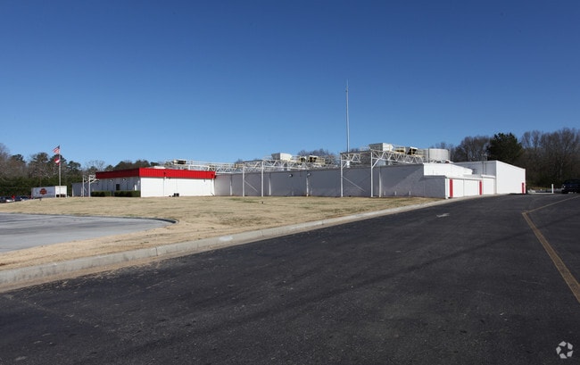
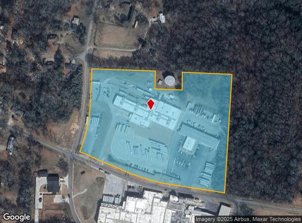
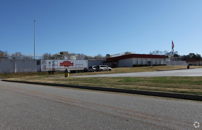
84 E Smithwood Dr
BE06-040
Oxford Ridge
Manufacturinglight
HARRISON HATCHERY
X
Barrow
13297C0040E
Georgia
2025
17.58 AC
2025
S Barrow
180503
Atlanta
47,130 SF
Atlanta-Sandy Springs-Roswell, GA
DEMOGRAPHICS near 84 E Smithwood Dr
1 Mile
3 Mile
5 Mile
2024 Total Population
1,188
10,762
41,988
2029 Population
1,383
12,556
49,122
Pop Growth 2024-2029
+ 16.41%
+ 16.67%
+ 16.99%
Average Age
37
37
37
2024 Total Households
402
3,530
14,345
HH Growth 2024-2029
+ 16.67%
+ 16.83%
+ 17.15%
Median Household Inc
$57,802
$67,107
$64,016
Avg Household Size
2.90
2.90
2.90
2024 Avg HH Vehicles
3.00
2.00
2.00
Median Home Value
$204,839
$225,000
$217,025
Median Year Built
1995
2000
2000
Nearby Places
Map Layers
Map Styles
 Street
 Aerial
- Restaurants
- Banks
- Shops
- Fitness
- Groceries
Nearby Properties
Address
Land Use
TOTAL SIZE
Lot Size
Zoning
Address
Land Use
TOTAL SIZE
Lot Size
Zoning
275,840 SF
22.10 AC
M-1
Address
Land Use
TOTAL SIZE
Lot Size
Zoning
26,789 SF
35.64 AC
C-3
Address
Land Use
TOTAL SIZE
Lot Size
Zoning
66,052 SF
30.25 AC
AG
Address
Land Use
TOTAL SIZE
Lot Size
Zoning
85,000 SF
85.91 AC
AC
Address
Land Use
TOTAL SIZE
Lot Size
Zoning
2,046 SF
12.97 AC
B-2,R-3
Address
Land Use
TOTAL SIZE
Lot Size
Zoning
132,156 SF
10.05 AC
C-2
Address
Land Use
TOTAL SIZE
Lot Size
Zoning
79,029 SF
9.72 AC
C-2
Address
Land Use
TOTAL SIZE
Lot Size
Zoning
65,340 SF
11.81 AC
C-3
Address
Land Use
TOTAL SIZE
Lot Size
Zoning
3,370 SF
352.38 AC
G,TNPD
Address
Land Use
TOTAL SIZE
Lot Size
Zoning
37,162 SF
4.62 AC
R-3
Address
Land Use
TOTAL SIZE
Lot Size
Zoning
26,802 SF
5 AC
AG
Address
Land Use
TOTAL SIZE
Lot Size
Zoning
20,857 SF
39.58 AC
M-1
Address
Land Use
TOTAL SIZE
Lot Size
Zoning
24,982 SF
16.08 AC
R-1
Address
Land Use
TOTAL SIZE
Lot Size
Zoning
8,916 SF
67.07 AC
R-3
Address
Land Use
TOTAL SIZE
Lot Size
Zoning
46,339 SF
2 AC
B-2
Address
Land Use
TOTAL SIZE
Lot Size
Zoning
76,768 SF
19.04 AC
AG
Address
Land Use
TOTAL SIZE
Lot Size
Zoning
45,296 SF
8.18 AC
B-2
Address
Land Use
TOTAL SIZE
Lot Size
Zoning
143,025 SF
9.30 AC
M-1
Address
Land Use
TOTAL SIZE
Lot Size
Zoning
19,483 SF
2.76 AC
B-2
Address
Land Use
TOTAL SIZE
Lot Size
Zoning
34,355 SF
24.48 AC
AG
Address
Land Use
TOTAL SIZE
Lot Size
Zoning
18,240 SF
0.97 AC
B-2
Address
Land Use
TOTAL SIZE
Lot Size
Zoning
33.15 AC
C-3
Address
Land Use
TOTAL SIZE
Lot Size
Zoning
4,026 SF
1.58 AC
B-2
Address
Land Use
TOTAL SIZE
Lot Size
Zoning
14,356 SF
2.29 AC
B-2
Address
Land Use
TOTAL SIZE
Lot Size
Zoning
13,439 SF
1.34 AC
B-2
Address
Land Use
TOTAL SIZE
Lot Size
Zoning
10,455 SF
1.97 AC
B-2
Address
Land Use
TOTAL SIZE
Lot Size
Zoning
3,600 SF
3 AC
C-3
Address
Land Use
TOTAL SIZE
Lot Size
Zoning
11,928 SF
0.96 AC
B-2
Address
Land Use
TOTAL SIZE
Lot Size
Zoning
6,345 SF
1.84 AC
B-2
The World's #1 Commercial Real Estate Marketplace
Connect with us
© 2025 CoStar Group
The information above has been obtained from sources believed reliable. While we do not doubt its accuracy we have not verified it and make no guarantee, warranty or representation about it. It is your responsibility to independently confirm its accuracy and completeness. Any projections, opinions, assumptions, or estimates used are for example only and do not represent the current or future performance of the property. The value of this transaction to you depends on tax and other factors which should be evaluated by your tax, financial, and legal advisors. You and your advisors should conduct a careful, independent investigation of the property to determine to your satisfaction the suitability of the property for your needs.